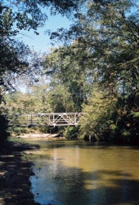
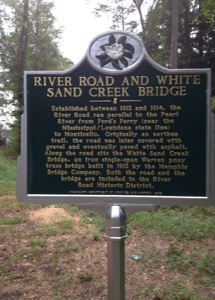
The River Road Historic District consists of approximately 5.56 miles of roadway from the junction of Highway 43 close to the China Lee Community to Conerly Road near Oak Vale, Mississippi. The original River Road (established between 1812 and 1814) ran north and south paralleling the Pearl River from Ford’s Ferry near the Line of Demarcation on the Pearl River (today’s Mississippi / Louisiana Stateline) to Monticello. River Road is one of the first north/south corridors and as such helped expand the Mississippi territory into the 20th state in the union. The majority of the old road has been lost to highway expansion and road widening; however, in this 5.56 mile segment, the original road bed width remains much as it was. A portion of the road just below China Lee is open land much like it was in the days of the Lynch, Martin and Douglas Plantations. In places, the road is narrow and sunken with earthen banks aligned with mature trees that are close to the road with a canopy effect. The mix of trees are pines and hardwood in the upland area while the bottomland forest of the White Sand Creek area consists of a mostly mature forest of red oak, white oak, white pines and magnolias. River Road presents the passerby with the impression of what the pioneer traveler experienced in the deep south of Mississippi in the yesteryears. These views into our past are rapidly disappearing from our landscape and history.


Preserve River Road in Lawrence County Mississippi